Enterprise Desktop Suite Windows 10 / 11 Certified (x64) 100% Offline Capable

EXOS GPS Station for Windows

Mission-Control Satellite GNSS Workstation & Windows Location Sensor Platform

Transform any standard Windows PC, rugged field laptop, or maritime command bridge into an industrial-grade satellite navigation workstation. Seamlessly connect external GNSS hardware, inject high-accuracy coordinates into the native Windows Location Services platform, track global orbital constellations in real-time 3D, and navigate 100% offline with zero cellular or cloud dependencies.

01 / CONNECTIVITY

Universal Hardware Pairing

Auto-discovers and bridges USB, Bluetooth SPP, and RS-232 serial GPS receivers (u-blox, Garmin, RTK) with zero manual COM port configuration.

02 / INTEGRATION

Windows Sensor Injection

Pipes satellite coordinates directly into native Windows Location Services so Google Maps, Microsoft Edge, and desktop GIS tools get instant hardware GPS.

03 / AUTONOMY

100% Offline Vector Maps

Complete situational awareness with zero internet. Integrated Natural Earth 110m vector geography, 3D compass rose, and dynamic artificial horizon.

04 / DIAGNOSTICS

Industrial NMEA 0183 Suite

Real-time serial stream terminal decoding $GPGGA, $GPRMC, and $GPGSV packets with CRC checksum verification for marine, survey, and field engineers.

Engineered for High-Reliability Operations

Designed from the ground up for maritime bridges, aerospace monitoring, disaster response, and field surveying where consumer apps fail.

PLUG-AND-PLAY HARDWARE HUB

Intelligent Port Discovery & Bluetooth SPP Bridge

Connect any GPS receiver to your Windows workstation in seconds without device manager headaches.

Traditional serial GPS software requires manual COM port matching, baud rate guessing, and registry digging. EXOS GPS Station eliminates this friction with an automated Windows Plug-and-Play (PnP) hardware scanner that enumerates all attached USB-to-Serial interfaces and RFCOMM Bluetooth Serial Port Profile (SPP) links instantly.

  • Automated PnP Hardware Scanner: 1-click port re-scan detects newly connected GPS dongles, RTK receivers, and handhelds.
  • Bluetooth SPP Cache Flusher: Purges stale or orphaned Windows Bluetooth serial ports with a single click.
  • Multi-Role Station Architecture: Toggle instantly between Autonomous Receiver Mode and Network Relay modes.
Field Operational Scenario: In high-pressure operations, plugging in a replacement GPS puck requires just clicking Rescan Ports and Connect Station. The system binds the serial stream and locks onto telemetry immediately.

Intelligent Port Discovery & Bluetooth SPP Hub
Native UI Crop • Hardware Connection Center 100% UNCOMPRESSED CRISP

SYSTEM-WIDE SENSOR DRIVER

Native Windows Location Sensor Platform Integration

Bridge external high-precision satellite telemetry directly into the Windows OS Location Subsystem.

Windows laptops do not have built-in GPS chips, leaving desktop applications and web browsers dependent on inaccurate Wi-Fi triangulation. EXOS GPS Station bridges your external high-gain satellite antenna directly into the native Windows Geolocation Service (Windows.Devices.Geolocation).

  • System-Wide Location Injection: Every Windows app—Google Maps in Chrome, Microsoft Edge, ArcGIS, and desktop tools—receives real hardware GPS.
  • One-Touch Google Maps Coordinate Launch: Opens the live browser map centered precisely on your active GPS coordinates.
  • Sub-Meter Field Accuracy: Overrides imprecise IP-based location estimation with genuine geodetic satellite fixes.
Business Value: Equipping field inspection teams or logistics fleets with rugged laptops no longer requires expensive cellular SIM contracts or proprietary GIS tracking hardware.
Native Windows Location Sensor Platform Integration
Native UI Crop • Location Sensor & Maps Bridge 100% UNCOMPRESSED CRISP
HIGH-PRECISION TELEMETRY

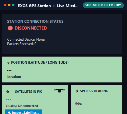
Live Tactical Telemetry Dashboard & Constellation Monitor

High-contrast, sunlight-readable instrumentation designed for cockpit, bridge, and field viewing.

Whether operating in direct sunlight on an open vessel or under low-light night-vision conditions, EXOS GPS Station provides razor-sharp, zero-latency situational metrics. The tactical dashboard renders essential geodetic coordinates, speed, heading, and altitude in bold, high-contrast digital cards.

  • Geodetic Fix Coordinates: Real-time Latitude and Longitude displayed with high decimal precision.
  • Dynamics Odometer: Real-time Ground Speed (km/h, knots, mph) and Course Over Ground (COG) heading.
  • Altitude Above MSL: Accurate Mean Sea Level elevation tracking for mountainous or aerial navigation.
  • Inspect Satellites Modal: One-click modal displaying individual satellite PRNs, elevation angles, and SNR signal levels.
Cockpit Legibility: High-contrast sage green cards with bold slate typography prevent eye strain and ensure immediate legibility in extreme lighting.
Live Mission Telemetry Dashboard & Constellation Monitor
Native UI Crop • Mission Telemetry Dashboard 100% UNCOMPRESSED CRISP
100% OFFLINE GEOGRAPHY

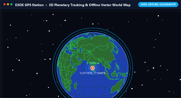
3D Planetary Constellation Tracking & Offline Vector World Map

Autonomous global situational awareness without internet, cellular coverage, or tile servers.

Most modern mapping applications fail the moment you lose internet access. EXOS GPS Station embeds a high-performance Natural Earth 110m vector world map and an interactive 3D celestial tracking globe directly into the client. Plot your vehicle's live position, ground track, and celestial satellites anywhere on the planet with complete independence from external servers.

  • Autonomous Vector Engine: Renders coastlines, country borders, and geographic grids completely off-grid.
  • 3D Orbital Constellation Radar: Visualizes real-time planetary satellite geometry and orbital passes.
  • 3D Artificial Horizon & Compass: Live pitch and roll attitude indicators paired with a dynamic azimuth rose.
Maritime & Remote Operations: Whether crossing mid-ocean passages or navigating deep backcountry terrain, your navigation display remains 100% operational.
3D Planetary Constellation Tracking & Offline Vector World Map
Native UI Crop • 3D Planetary Tracking & Vector Map 100% UNCOMPRESSED CRISP
PROTOCOL DIAGNOSTICS

Industrial NMEA 0183 Telemetry Stream & Protocol Analyzer

Real-time raw serial sentence inspection for marine electronics, surveyors, and field engineers.

For mission-critical installations, understanding raw signal integrity is paramount. EXOS GPS Station features an integrated high-speed terminal that decodes and displays standard NMEA 0183 serial sentences in real time. Validate baud rates, inspect raw payload strings, and verify packet CRC checksums without launching third-party terminal emulators.

  • Standard Sentence Support: Full parsing for $GPGGA (Fix Data), $GPRMC (Transit Data), $GPGSV (Satellites in View), and multi-GNSS sentences.
  • Packet Integrity & CRC Validation: Instant visual identification of dropped packets, parity errors, or serial noise.
  • Timestamped Telemetry Logging: Record mission telemetry to standard NMEA log files for post-operation GIS analysis.
Field Technician Tool: Rapidly diagnose whether a connection issue stems from antenna positioning, baud rate mismatch, or cable degradation within seconds.
Industrial NMEA 0183 Telemetry Stream Console
Native UI Crop • Live NMEA 0183 Serial Terminal 100% UNCOMPRESSED CRISP
TESTING & SIMULATION

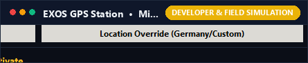
Field Mission Simulation & Custom Coordinate Override

Rehearse expeditions and validate software workflows from the comfort of your desk.

Testing location-aware Windows applications shouldn't require taking your laptop into the field or waiting for outdoor satellite lock. EXOS GPS Station features an integrated coordinate simulation engine that allows developers, navigators, and mission planners to inject synthetic geodetic trajectories directly into the Windows system.

  • Synthetic Position Injection: Override system coordinates with custom target locations or pre-set testing waypoints.
  • Geofence & Workflow Testing: Validate how your proprietary desktop software responds to boundary crossings.
  • Zero-Hardware Development: Build and debug location-dependent mapping systems without requiring a physical GPS puck.
Developer Efficiency: Seamlessly switch between genuine live hardware feeds and controlled simulations with a single toggle.
Field Mission Simulation & Custom Coordinate Override
Native UI Crop • Coordinate Override & Simulation 100% UNCOMPRESSED CRISP

Enterprise Architecture & Compatibility

Engineered for high performance, minimal CPU overhead, and standalone offline execution.

Operating System Windows 10, Windows 11 (64-bit Architecture, fully verified on build 22H2+)
Hardware Interfaces USB Serial (FTDI, Prolific, CP210x, CH340), Bluetooth SPP (RFCOMM), RS-232 COM Ports
Baud Rate Support Auto-detect and standard rates: 4800, 9600, 19200, 38400, 57600, 115200 bps
Supported Protocols NMEA 0183 standard sentences ($GPGGA, $GPRMC, $GPGSV, $GPGLL, $GPVTG, $GN* multi-constellation)
Windows Sensor Driver Native C# bridge binding directly to Windows.Devices.Geolocation subsystem
Mapping & Graphics Built-in Natural Earth 110m Vector Engine • Zero external tile servers or cloud required
Installation Package Self-contained Inno Setup Windows installer with desktop and start menu shortcuts • Zero bloatware

Ready to Upgrade Your Windows Navigation Bridge?

Download EXOS GPS Station today. Connect your satellite receiver, stream coordinates into Windows Location, and navigate with military-grade precision.

Download Free Evaluation for Windows (.exe) Return to Platform Overview →